NASA’s New Climate Satellite
NASA’s New Climate Satellite Hopes to Save Lives—and Maybe the Planet.
NASA wants to measure every raindrop and snowflake on Earth. Here’s why that matters.
The mission for NASA’s shiniest new toy doesn’t sound all that compelling. The Global Precipitation Measurement satellite “will be used to unify precipitation measurements made by an international network of partner satellites,” the space agency says on its website. But don’t be fooled by the science jargon; GPM’s mission is supercool—and super-important.
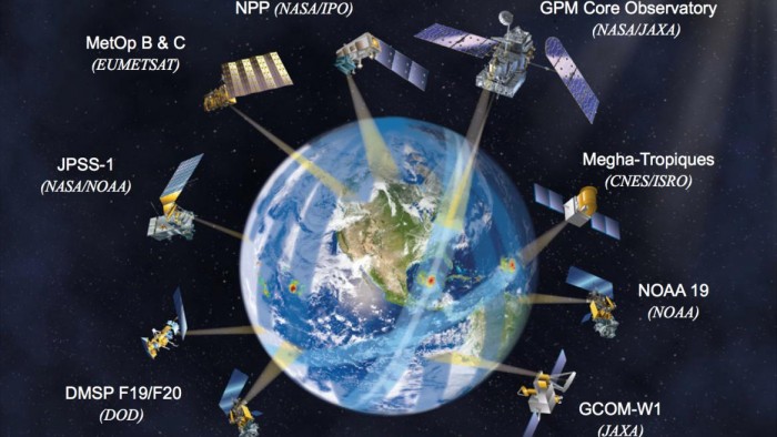
The satellite, a product of NASA’s Goddard Space Flight Center and the Japan Aerospace Exploration Agency, will blast off from Tanegashima, Japan, on Thursday afternoon. It’s the cornerstone of a mission to track all precipitation on Earth, with real-time measurements every three hours. Why that’s meaningful probably escapes most of us who haven’t studied the water cycle since elementary school. We’ll let the scientists explain.
“Knowing where, when, and how much it’s snowing and raining around the world is extremely important for understanding extreme events like blizzards, or drought in California, monsoon rains in Asia,” said Dalia Kirschbaum, GPM’s mission applications scientist. “So by having the global picture, all the way from what’s happening in our atmosphere around the planet down to what’s happening in my backyard—it gives us really powerful information to tell us about weather, about how our climate is changing and how we can improve our understanding and mitigation of natural hazards.”
For example, NASA satellites tracked Hurricane Sandy’s makeup in 2012—until it passed Florida and headed north. That’s where it left the range of the Tropical Rainfall Measuring Mission. That mission is the precursor to GPM, and gave NASA its first chance to “look three-dimensionally through storms and look at the actual internal dynamics and intensity of a hurricane, for example,” Kirschbaum said. “It gives you a lot of information about how it might be intensifying and where it’s going.”
With GPM and its partner satellites in the sky, that information will soon be available at every point on the globe. If it works as expected, it will provide more accurate monitoring of catastrophic weather and better forecasting of future events.
By being able to see exactly what’s going on today, that’s how we improve our models to forecast what will happen tomorrow,” said Candace Carlisle, the mission’s deputy project manager. “GPM and our partnership with all of the data from the various spacecraft will in fact help save lives.”
In the long-term, that information will also help track how climate change is affecting Earth’s most precious resource. “[GPM] is critical for long-term—what are we looking at over time, over decades, how is precipitation changing?” Kirschbaum said. “GPM provides that important data, that long-term record … to give us that picture, to put data into models or computer programs that can estimate where areas might be getting wetter, where they might be getting drier. There’s still a lot of unknowns about what’s going to happen to our climate system in a changing climate.”
How important is it to know where our water is going? Its necessity for survival is obvious, but water’s importance becomes magnified when you realize its comparative scarcity. Less than 1 percent of the water on Earth is accessible freshwater.
For farmers in developing countries or residents in landslide- or monsoon-prone regions, understanding its cycle—and how that might change along with the climate—is essential for life.
So how does NASA collect all this data? GPM uses a pair of instruments to gather both wide-ranging and super-precise information. Its microwave imager gives scientists a two-dimensional look at a 562-mile swath of Earth. Meanwhile, dual-frequency precipitation radar provides three-dimensional modeling; one radar band will cover a 152-mile swath, the other will see a narrower 75 miles within that. GPM will orbit 250 miles above Earth.
In addition to extending the range from the TRMM mission, GPM will be able to better detect light rain and falling snow. With that precision information, NASA will be able to make better use of the other satellites in its fleet. When they cross the same weather patterns, scientists can compare data—and use it to recalibrate the measurements it’s getting from other satellites. “[GPM] crosses over the orbits of all of the other spacecraft,” Carlisle said. “We’ll have a calibration standard for all of the other spacecraft in the constellation.”
But before GPM can start sending back hyper-precise data, it will first have to get off the ground. After it leaves the launchpad and separates from its Japanese rocket, the scientists at Goddard will take over. They’re preparing for a tense couple weeks of putting it through its paces, testing its instruments and navigation.
Thursday’s launch will be the culmination of years of planning, building, and testing for NASA’s GPM crew. It’s the largest satellite built and assembled at the Goddard facility. But scientists didn’t take it easy on their biggest toy as they prepared it for launch.
First, they put it in a vacuum-sealed container and heated it to 212 degrees Fahrenheit. Then they turned the thermostat down to -320. After that, the scientists pounded it with electromagnetic interference to make sure its instruments would still function. A vibration test confirmed its readiness for the shakes of launch. Finally, a ginormous speaker with a gaping mouth the size of a subway tunnel blasted it with extremely loud sound.
Only after it passed all those tests was GPM ready to ship to Japan.
In a few days, GPM will start sending back its one-of-a-kind data, and the team at Goddard can’t wait—even if they put it in terms that would only excite a NASA scientist. “This isn’t just another weather satellite,” Kirschbaum said. “It’s a physics observatory in space.”
By Alex Brown and Reena Flores


